|
|
|||||||||||||||||
| Point ID: 7382 | Downloads | Plots | Site Data | Code: 70172 |
|
|
|||||||||||||||||
| Download | |
|---|---|
| Site Descriptor Information | Site Time Series Data |
| Link to all available data | |
| View: | Time Series | All |
| Units: | m3/s |
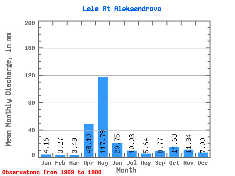
| Statistic | Jan | Feb | Mar | Apr | May | Jun | Jul | Aug | Sep | Oct | Nov | Dec | Annual |
|---|---|---|---|---|---|---|---|---|---|---|---|---|---|
| Mean | 4.16 | 3.30 | 3.49 | 48.10 | 117.77 | 20.75 | 10.03 | 5.64 | 8.78 | 14.63 | 11.34 | 7.00 | 253.31 |
| Standard Deviation | 1.16 | 0.77 | 0.71 | 41.23 | 60.05 | 14.61 | 6.41 | 3.44 | 5.70 | 9.32 | 6.85 | 3.44 | 46.33 |
| Min | 2.61 | 2.06 | 2.13 | 3.62 | 19.86 | 4.82 | 2.77 | 2.77 | 3.18 | 4.84 | 3.57 | 3.39 | 171.39 |
| Max | 6.33 | 4.71 | 5.11 | 152.13 | 261.34 | 65.39 | 23.60 | 16.88 | 22.79 | 31.22 | 24.04 | 16.53 | 356.89 |
| Coefficient of Variation | 0.28 | 0.23 | 0.20 | 0.86 | 0.51 | 0.70 | 0.64 | 0.61 | 0.65 | 0.64 | 0.60 | 0.49 | 0.18 |
 Return to R-Arctic Net Home Page