|
|
|||||||||||||||||
| Point ID: 7380 | Downloads | Plots | Site Data | Code: 70167 |
|
|
|||||||||||||||||
| Download | |
|---|---|
| Site Descriptor Information | Site Time Series Data |
| Link to all available data | |
| View: | Time Series | All |
| Units: | m3/s |
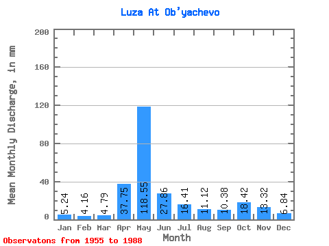
| Statistic | Jan | Feb | Mar | Apr | May | Jun | Jul | Aug | Sep | Oct | Nov | Dec | Annual |
|---|---|---|---|---|---|---|---|---|---|---|---|---|---|
| Mean | 5.24 | 4.20 | 4.79 | 37.75 | 118.53 | 27.86 | 16.41 | 11.12 | 10.38 | 18.41 | 13.32 | 6.84 | 272.49 |
| Standard Deviation | 2.65 | 1.53 | 1.52 | 28.65 | 53.47 | 19.21 | 10.15 | 10.03 | 6.55 | 12.10 | 8.84 | 3.47 | 76.39 |
| Min | 1.67 | 1.83 | 2.37 | 4.49 | 30.98 | 6.50 | 4.72 | 3.68 | 3.20 | 5.68 | 2.94 | 2.50 | 130.37 |
| Max | 14.35 | 8.52 | 9.75 | 110.26 | 266.60 | 96.33 | 46.77 | 51.56 | 27.85 | 46.37 | 36.25 | 18.59 | 449.14 |
| Coefficient of Variation | 0.51 | 0.36 | 0.32 | 0.76 | 0.45 | 0.69 | 0.62 | 0.90 | 0.63 | 0.66 | 0.66 | 0.51 | 0.28 |
 Return to R-Arctic Net Home Page