|
|
|||||||||||||||||
| Point ID: 7374 | Downloads | Plots | Site Data | Code: 70158 |
|
|
|||||||||||||||||
| Download | |
|---|---|
| Site Descriptor Information | Site Time Series Data |
| Link to all available data | |
| View: | Time Series | All |
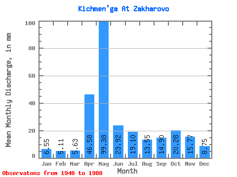
| Units: | m3/s |
| Statistic | Jan | Feb | Mar | Apr | May | Jun | Jul | Aug | Sep | Oct | Nov | Dec | Annual |
|---|---|---|---|---|---|---|---|---|---|---|---|---|---|
| Mean | 6.55 | 5.16 | 5.63 | 46.58 | 99.36 | 23.92 | 19.10 | 13.54 | 14.90 | 20.28 | 15.77 | 8.75 | 278.32 |
| Standard Deviation | 1.93 | 1.22 | 1.20 | 30.62 | 47.58 | 13.79 | 15.65 | 10.29 | 14.70 | 15.03 | 9.36 | 3.61 | 75.29 |
| Min | 3.42 | 3.13 | 3.49 | 7.25 | 21.45 | 5.52 | 4.53 | 5.29 | 5.11 | 7.17 | 5.09 | 4.08 | 164.38 |
| Max | 12.82 | 8.89 | 9.77 | 118.64 | 218.50 | 64.61 | 76.34 | 57.02 | 90.40 | 91.93 | 45.65 | 21.18 | 596.37 |
| Coefficient of Variation | 0.29 | 0.24 | 0.21 | 0.66 | 0.48 | 0.58 | 0.82 | 0.76 | 0.99 | 0.74 | 0.59 | 0.41 | 0.27 |
 Return to R-Arctic Net Home Page