|
|
|||||||||||||||||
| Point ID: 7373 | Downloads | Plots | Site Data | Code: 70156 |
|
|
|||||||||||||||||
| Download | |
|---|---|
| Site Descriptor Information | Site Time Series Data |
| Link to all available data | |
| View: | Time Series | All |
| Units: | m3/s |
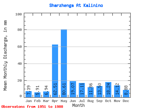
| Statistic | Jan | Feb | Mar | Apr | May | Jun | Jul | Aug | Sep | Oct | Nov | Dec | Annual |
|---|---|---|---|---|---|---|---|---|---|---|---|---|---|
| Mean | 7.39 | 5.96 | 6.94 | 62.51 | 80.60 | 19.07 | 17.11 | 11.86 | 13.50 | 18.24 | 14.12 | 8.88 | 266.32 |
| Standard Deviation | 1.85 | 1.27 | 2.35 | 30.96 | 46.65 | 13.81 | 16.98 | 8.29 | 12.11 | 15.61 | 9.25 | 2.82 | 70.72 |
| Min | 4.89 | 4.07 | 4.52 | 11.42 | 13.62 | 5.31 | 5.16 | 4.78 | 5.41 | 5.94 | 5.43 | 4.51 | 149.77 |
| Max | 12.09 | 9.79 | 19.18 | 155.69 | 186.37 | 69.88 | 90.29 | 50.48 | 60.60 | 83.96 | 49.39 | 16.38 | 478.07 |
| Coefficient of Variation | 0.25 | 0.21 | 0.34 | 0.49 | 0.58 | 0.72 | 0.99 | 0.70 | 0.90 | 0.86 | 0.66 | 0.32 | 0.27 |
 Return to R-Arctic Net Home Page