|
|
|||||||||||||||||
| Point ID: 737 | Downloads | Plots | Site Data | Code: 07FD908 |
|
|
|||||||||||||||||
| Download | |
|---|---|
| Site Descriptor Information | Site Time Series Data |
| Link to all available data | |
| View: | Time Series | All |
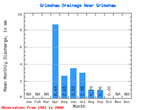
| Units: | m3/s |
| Statistic | Jan | Feb | Mar | Apr | May | Jun | Jul | Aug | Sep | Oct | Nov | Dec | Annual |
|---|---|---|---|---|---|---|---|---|---|---|---|---|---|
| Mean | 8.77 | 2.74 | 3.52 | 2.88 | 0.93 | 1.06 | 0.14 | ||||||
| Standard Deviation | 7.49 | 4.58 | 5.29 | 2.54 | 0.78 | 1.52 | 0.18 | ||||||
| Min | 0.00 | 0.33 | 0.00 | 0.33 | 0.00 | 0.00 | 0.00 | ||||||
| Max | 19.84 | 14.88 | 17.92 | 7.27 | 2.31 | 4.80 | 0.33 | ||||||
| Coefficient of Variation | 0.85 | 1.67 | 1.50 | 0.88 | 0.84 | 1.44 | 1.25 |
 Return to R-Arctic Net Home Page