|
|
|||||||||||||||||
| Point ID: 7368 | Downloads | Plots | Site Data | Code: 70148 |
|
|
|||||||||||||||||
| Download | |
|---|---|
| Site Descriptor Information | Site Time Series Data |
| Link to all available data | |
| View: | Time Series | All |
| Units: | m3/s |
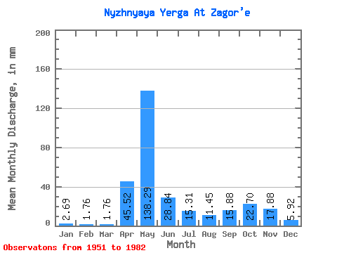
| Statistic | Jan | Feb | Mar | Apr | May | Jun | Jul | Aug | Sep | Oct | Nov | Dec | Annual |
|---|---|---|---|---|---|---|---|---|---|---|---|---|---|
| Mean | 2.69 | 1.77 | 1.76 | 45.52 | 138.27 | 28.84 | 15.31 | 11.45 | 15.88 | 22.70 | 17.89 | 5.92 | 306.74 |
| Standard Deviation | 0.96 | 0.66 | 0.55 | 38.88 | 64.55 | 18.61 | 14.41 | 19.90 | 26.35 | 18.51 | 15.32 | 5.32 | 104.52 |
| Min | 1.46 | 0.93 | 0.63 | 1.84 | 25.46 | 6.60 | 2.82 | 2.44 | 2.31 | 4.29 | 2.88 | 1.61 | 163.16 |
| Max | 6.13 | 4.30 | 3.21 | 137.61 | 245.89 | 86.24 | 57.45 | 85.70 | 143.27 | 93.97 | 70.69 | 27.80 | 716.41 |
| Coefficient of Variation | 0.36 | 0.37 | 0.31 | 0.85 | 0.47 | 0.65 | 0.94 | 1.74 | 1.66 | 0.81 | 0.86 | 0.90 | 0.34 |
 Return to R-Arctic Net Home Page