|
|
|||||||||||||||||
| Point ID: 7367 | Downloads | Plots | Site Data | Code: 70147 |
|
|
|||||||||||||||||
| Download | |
|---|---|
| Site Descriptor Information | Site Time Series Data |
| Link to all available data | |
| View: | Time Series | All |
| Units: | m3/s |
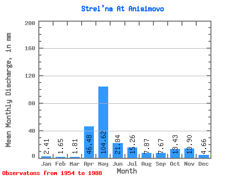
| Statistic | Jan | Feb | Mar | Apr | May | Jun | Jul | Aug | Sep | Oct | Nov | Dec | Annual |
|---|---|---|---|---|---|---|---|---|---|---|---|---|---|
| Mean | 2.41 | 1.66 | 1.81 | 46.48 | 104.60 | 21.84 | 15.26 | 7.87 | 7.67 | 13.43 | 13.90 | 4.66 | 240.35 |
| Standard Deviation | 1.53 | 0.83 | 1.01 | 36.45 | 55.90 | 18.88 | 17.27 | 10.12 | 7.06 | 8.95 | 10.64 | 3.54 | 65.53 |
| Min | 0.55 | 0.50 | 0.62 | 2.49 | 17.91 | 2.32 | 1.61 | 1.88 | 2.02 | 2.53 | 2.22 | 1.47 | 123.16 |
| Max | 9.21 | 3.68 | 5.62 | 161.09 | 221.57 | 81.87 | 67.12 | 48.63 | 33.81 | 37.67 | 47.73 | 20.10 | 341.97 |
| Coefficient of Variation | 0.64 | 0.50 | 0.56 | 0.78 | 0.53 | 0.86 | 1.13 | 1.29 | 0.92 | 0.67 | 0.77 | 0.76 | 0.27 |
 Return to R-Arctic Net Home Page