|
|
|||||||||||||||||
| Point ID: 7364 | Downloads | Plots | Site Data | Code: 70140 |
|
|
|||||||||||||||||
| Download | |
|---|---|
| Site Descriptor Information | Site Time Series Data |
| Link to all available data | |
| View: | Time Series | All |
| Units: | m3/s |
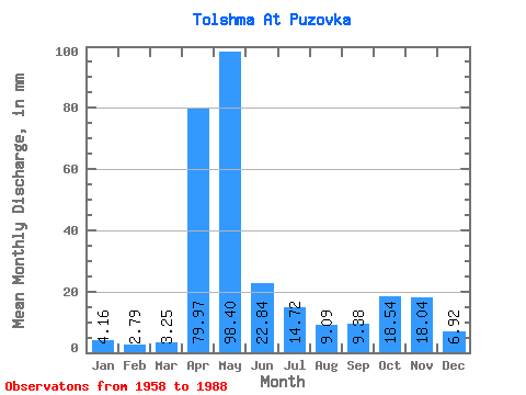
| Statistic | Jan | Feb | Mar | Apr | May | Jun | Jul | Aug | Sep | Oct | Nov | Dec | Annual |
|---|---|---|---|---|---|---|---|---|---|---|---|---|---|
| Mean | 4.16 | 2.81 | 3.25 | 79.97 | 98.39 | 22.84 | 14.72 | 9.09 | 9.38 | 18.54 | 18.04 | 6.92 | 287.44 |
| Standard Deviation | 2.74 | 1.36 | 1.89 | 50.14 | 64.04 | 26.07 | 16.83 | 12.88 | 10.28 | 19.05 | 15.93 | 5.00 | 101.65 |
| Min | 1.31 | 1.20 | 1.48 | 7.35 | 9.86 | 3.18 | 1.29 | 0.76 | 0.94 | 1.95 | 1.70 | 1.95 | 137.05 |
| Max | 14.00 | 7.79 | 11.37 | 202.18 | 262.93 | 126.77 | 76.69 | 59.65 | 43.83 | 94.95 | 66.21 | 21.08 | 569.97 |
| Coefficient of Variation | 0.66 | 0.48 | 0.58 | 0.63 | 0.65 | 1.14 | 1.14 | 1.42 | 1.10 | 1.03 | 0.88 | 0.72 | 0.35 |
 Return to R-Arctic Net Home Page