|
|
|||||||||||||||||
| Point ID: 7362 | Downloads | Plots | Site Data | Code: 70135 |
|
|
|||||||||||||||||
| Download | |
|---|---|
| Site Descriptor Information | Site Time Series Data |
| Link to all available data | |
| View: | Time Series | All |
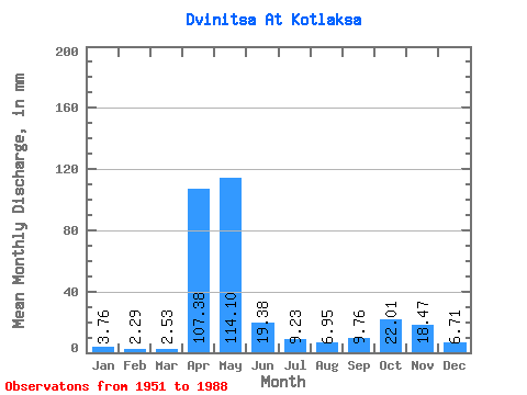
| Units: | m3/s |
| Statistic | Jan | Feb | Mar | Apr | May | Jun | Jul | Aug | Sep | Oct | Nov | Dec | Annual |
|---|---|---|---|---|---|---|---|---|---|---|---|---|---|
| Mean | 3.76 | 2.31 | 2.53 | 107.38 | 114.08 | 19.38 | 9.23 | 6.95 | 9.76 | 22.01 | 18.47 | 6.71 | 323.75 |
| Standard Deviation | 2.89 | 1.52 | 1.57 | 62.81 | 73.61 | 21.88 | 8.29 | 10.20 | 12.47 | 20.58 | 17.05 | 5.14 | 92.76 |
| Min | 0.49 | 0.31 | 0.68 | 10.32 | 8.04 | 1.79 | 1.11 | 1.05 | 0.81 | 1.51 | 1.19 | 1.02 | 180.13 |
| Max | 12.79 | 6.29 | 7.24 | 232.06 | 329.74 | 98.73 | 30.48 | 43.76 | 43.25 | 80.74 | 68.60 | 18.58 | 479.48 |
| Coefficient of Variation | 0.77 | 0.66 | 0.62 | 0.58 | 0.65 | 1.13 | 0.90 | 1.47 | 1.28 | 0.94 | 0.92 | 0.77 | 0.29 |
 Return to R-Arctic Net Home Page