|
|
|||||||||||||||||
| Point ID: 7360 | Downloads | Plots | Site Data | Code: 70129 |
|
|
|||||||||||||||||
| Download | |
|---|---|
| Site Descriptor Information | Site Time Series Data |
| Link to all available data | |
| View: | Time Series | All |
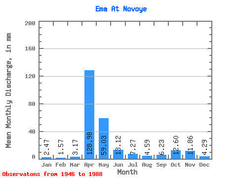
| Units: | m3/s |
| Statistic | Jan | Feb | Mar | Apr | May | Jun | Jul | Aug | Sep | Oct | Nov | Dec | Annual |
|---|---|---|---|---|---|---|---|---|---|---|---|---|---|
| Mean | 2.46 | 1.58 | 3.17 | 128.97 | 59.02 | 13.12 | 7.28 | 4.60 | 6.22 | 12.60 | 11.86 | 4.29 | 255.98 |
| Standard Deviation | 2.48 | 1.53 | 3.85 | 54.79 | 50.82 | 19.02 | 10.95 | 8.64 | 10.06 | 14.51 | 15.88 | 3.73 | 80.13 |
| Min | 0.43 | 0.22 | 0.46 | 25.05 | 2.10 | 0.51 | 0.10 | 0.15 | 0.16 | 0.21 | 0.16 | 0.39 | 89.77 |
| Max | 12.12 | 8.45 | 15.71 | 257.75 | 184.02 | 87.75 | 56.40 | 51.02 | 44.89 | 60.59 | 77.47 | 15.71 | 491.55 |
| Coefficient of Variation | 1.01 | 0.96 | 1.22 | 0.42 | 0.86 | 1.45 | 1.50 | 1.88 | 1.62 | 1.15 | 1.34 | 0.87 | 0.31 |
 Return to R-Arctic Net Home Page