|
|
|||||||||||||||||
| Point ID: 7358 | Downloads | Plots | Site Data | Code: 70124 |
|
|
|||||||||||||||||
| Download | |
|---|---|
| Site Descriptor Information | Site Time Series Data |
| Link to all available data | |
| View: | Time Series | All |
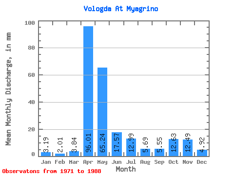
| Units: | m3/s |
| Statistic | Jan | Feb | Mar | Apr | May | Jun | Jul | Aug | Sep | Oct | Nov | Dec | Annual |
|---|---|---|---|---|---|---|---|---|---|---|---|---|---|
| Mean | 3.19 | 2.03 | 3.84 | 96.01 | 65.23 | 17.57 | 12.99 | 5.69 | 5.54 | 12.62 | 12.49 | 4.91 | 244.68 |
| Standard Deviation | 2.96 | 1.58 | 5.47 | 41.65 | 54.49 | 27.52 | 18.54 | 8.10 | 7.43 | 15.08 | 11.53 | 3.45 | 73.17 |
| Min | 0.25 | 0.36 | 0.21 | 34.49 | 2.95 | 1.35 | 0.42 | 0.19 | 0.29 | 0.74 | 1.00 | 0.76 | 112.67 |
| Max | 11.87 | 4.80 | 23.20 | 169.81 | 175.65 | 105.11 | 67.90 | 28.89 | 22.04 | 56.09 | 37.35 | 13.49 | 350.25 |
| Coefficient of Variation | 0.93 | 0.78 | 1.43 | 0.43 | 0.83 | 1.57 | 1.43 | 1.42 | 1.34 | 1.20 | 0.92 | 0.70 | 0.30 |
 Return to R-Arctic Net Home Page