|
|
|||||||||||||||||
| Point ID: 7357 | Downloads | Plots | Site Data | Code: 70121 |
|
|
|||||||||||||||||
| Download | |
|---|---|
| Site Descriptor Information | Site Time Series Data |
| Link to all available data | |
| View: | Time Series | All |
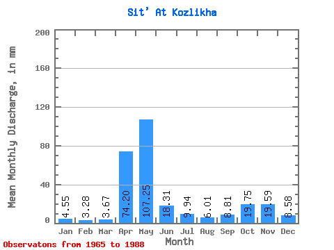
| Units: | m3/s |
| Statistic | Jan | Feb | Mar | Apr | May | Jun | Jul | Aug | Sep | Oct | Nov | Dec | Annual |
|---|---|---|---|---|---|---|---|---|---|---|---|---|---|
| Mean | 4.55 | 3.31 | 3.67 | 74.20 | 107.23 | 18.31 | 9.94 | 6.01 | 8.81 | 19.75 | 19.59 | 8.57 | 284.60 |
| Standard Deviation | 3.06 | 2.03 | 2.47 | 47.49 | 59.41 | 15.41 | 9.72 | 5.36 | 8.82 | 18.26 | 16.83 | 6.82 | 82.61 |
| Min | 1.29 | 1.09 | 1.20 | 3.79 | 14.61 | 2.81 | 0.52 | 0.54 | 0.45 | 0.59 | 0.96 | 1.44 | 146.12 |
| Max | 12.09 | 8.75 | 11.89 | 191.88 | 227.80 | 55.71 | 35.13 | 20.52 | 30.13 | 59.65 | 56.89 | 30.08 | 480.66 |
| Coefficient of Variation | 0.67 | 0.61 | 0.67 | 0.64 | 0.55 | 0.84 | 0.98 | 0.89 | 1.00 | 0.93 | 0.86 | 0.80 | 0.29 |
 Return to R-Arctic Net Home Page