|
|
|||||||||||||||||
| Point ID: 7355 | Downloads | Plots | Site Data | Code: 70118 |
|
|
|||||||||||||||||
| Download | |
|---|---|
| Site Descriptor Information | Site Time Series Data |
| Link to all available data | |
| View: | Time Series | All |
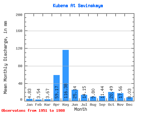
| Units: | m3/s |
| Statistic | Jan | Feb | Mar | Apr | May | Jun | Jul | Aug | Sep | Oct | Nov | Dec | Annual |
|---|---|---|---|---|---|---|---|---|---|---|---|---|---|
| Mean | 4.83 | 3.58 | 3.67 | 59.17 | 116.37 | 25.14 | 14.15 | 9.79 | 11.44 | 20.49 | 17.56 | 8.03 | 292.98 |
| Standard Deviation | 2.57 | 1.34 | 0.92 | 43.10 | 58.73 | 18.25 | 11.80 | 11.38 | 11.31 | 15.45 | 12.86 | 6.15 | 76.95 |
| Min | 2.66 | 2.15 | 2.23 | 4.46 | 19.56 | 3.77 | 2.13 | 1.87 | 2.62 | 2.90 | 2.67 | 2.57 | 177.66 |
| Max | 17.03 | 7.98 | 5.90 | 166.93 | 264.49 | 74.13 | 51.85 | 62.27 | 53.33 | 61.16 | 49.17 | 26.50 | 445.42 |
| Coefficient of Variation | 0.53 | 0.38 | 0.25 | 0.73 | 0.51 | 0.73 | 0.83 | 1.16 | 0.99 | 0.75 | 0.73 | 0.77 | 0.26 |
 Return to R-Arctic Net Home Page