|
|
|||||||||||||||||
| Point ID: 7346 | Downloads | Plots | Site Data | Code: 70047 |
|
|
|||||||||||||||||
| Download | |
|---|---|
| Site Descriptor Information | Site Time Series Data |
| Link to all available data | |
| View: | Time Series | All |
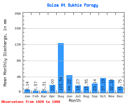
| Units: | m3/s |
| Statistic | Jan | Feb | Mar | Apr | May | Jun | Jul | Aug | Sep | Oct | Nov | Dec | Annual |
|---|---|---|---|---|---|---|---|---|---|---|---|---|---|
| Mean | 8.14 | 5.62 | 5.31 | 20.00 | 123.52 | 44.22 | 18.27 | 15.95 | 23.14 | 37.19 | 32.19 | 15.75 | 343.03 |
| Standard Deviation | 3.10 | 2.53 | 2.15 | 22.67 | 42.74 | 24.32 | 10.84 | 12.05 | 17.76 | 20.99 | 19.85 | 8.94 | 83.28 |
| Min | 2.52 | 1.87 | 1.80 | 2.92 | 27.23 | 12.59 | 3.65 | 2.72 | 2.83 | 4.50 | 5.38 | 4.77 | 181.14 |
| Max | 17.69 | 14.07 | 13.21 | 111.30 | 227.29 | 133.52 | 43.88 | 49.06 | 94.75 | 101.72 | 105.42 | 52.66 | 535.88 |
| Coefficient of Variation | 0.38 | 0.45 | 0.41 | 1.13 | 0.35 | 0.55 | 0.59 | 0.76 | 0.77 | 0.56 | 0.62 | 0.57 | 0.24 |
 Return to R-Arctic Net Home Page