|
|
|||||||||||||||||
| Point ID: 7345 | Downloads | Plots | Site Data | Code: 70043 |
|
|
|||||||||||||||||
| Download | |
|---|---|
| Site Descriptor Information | Site Time Series Data |
| Link to all available data | |
| View: | Time Series | All |
| Units: | m3/s |
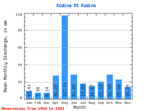
| Statistic | Jan | Feb | Mar | Apr | May | Jun | Jul | Aug | Sep | Oct | Nov | Dec | Annual |
|---|---|---|---|---|---|---|---|---|---|---|---|---|---|
| Mean | 10.41 | 8.05 | 8.14 | 30.22 | 106.99 | 31.20 | 19.88 | 16.67 | 22.13 | 31.49 | 25.06 | 15.39 | 324.07 |
| Standard Deviation | 2.63 | 1.72 | 1.37 | 28.31 | 39.96 | 12.10 | 9.86 | 8.74 | 14.31 | 16.11 | 11.20 | 6.91 | 70.56 |
| Min | 6.00 | 5.30 | 5.94 | 6.22 | 23.95 | 13.79 | 9.49 | 6.63 | 7.82 | 7.77 | 6.16 | 7.05 | 196.97 |
| Max | 17.70 | 12.39 | 11.43 | 108.86 | 196.39 | 53.71 | 50.14 | 43.15 | 73.44 | 71.86 | 49.68 | 31.54 | 469.45 |
| Coefficient of Variation | 0.25 | 0.21 | 0.17 | 0.94 | 0.37 | 0.39 | 0.50 | 0.52 | 0.65 | 0.51 | 0.45 | 0.45 | 0.22 |
 Return to R-Arctic Net Home Page