|
|
|||||||||||||||||
| Point ID: 7344 | Downloads | Plots | Site Data | Code: 70036 |
|
|
|||||||||||||||||
| Download | |
|---|---|
| Site Descriptor Information | Site Time Series Data |
| Link to all available data | |
| View: | Time Series | All |
| Units: | m3/s |
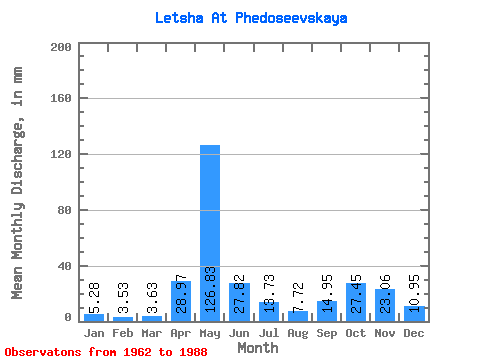
| Statistic | Jan | Feb | Mar | Apr | May | Jun | Jul | Aug | Sep | Oct | Nov | Dec | Annual |
|---|---|---|---|---|---|---|---|---|---|---|---|---|---|
| Mean | 5.28 | 3.56 | 3.63 | 28.97 | 126.81 | 27.82 | 13.73 | 7.72 | 14.95 | 27.44 | 23.06 | 10.95 | 291.48 |
| Standard Deviation | 2.51 | 1.54 | 1.57 | 36.23 | 37.09 | 13.56 | 10.70 | 4.52 | 11.58 | 18.46 | 15.73 | 8.23 | 64.78 |
| Min | 1.80 | 1.50 | 1.83 | 2.69 | 57.01 | 8.11 | 2.94 | 1.94 | 2.57 | 3.98 | 3.77 | 2.25 | 180.90 |
| Max | 13.20 | 7.37 | 9.20 | 151.16 | 195.68 | 51.84 | 41.36 | 14.93 | 50.56 | 74.77 | 59.80 | 38.45 | 438.64 |
| Coefficient of Variation | 0.47 | 0.43 | 0.43 | 1.25 | 0.29 | 0.49 | 0.78 | 0.59 | 0.78 | 0.67 | 0.68 | 0.75 | 0.22 |
 Return to R-Arctic Net Home Page