|
|
|||||||||||||||||
| Point ID: 7334 | Downloads | Plots | Site Data | Code: 70004 |
|
|
|||||||||||||||||
| Download | |
|---|---|
| Site Descriptor Information | Site Time Series Data |
| Link to all available data | |
| View: | Time Series | All |
| Units: | m3/s |
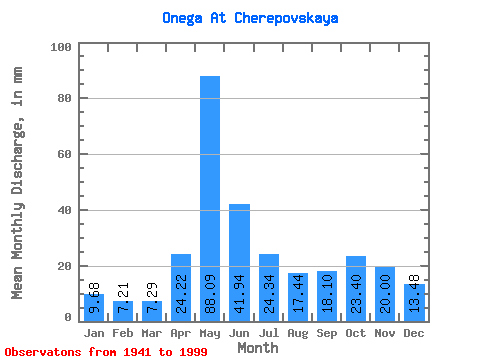
| Statistic | Jan | Feb | Mar | Apr | May | Jun | Jul | Aug | Sep | Oct | Nov | Dec | Annual |
|---|---|---|---|---|---|---|---|---|---|---|---|---|---|
| Mean | 9.68 | 7.27 | 7.29 | 24.22 | 88.08 | 41.94 | 24.34 | 17.44 | 18.10 | 23.40 | 20.00 | 13.48 | 293.37 |
| Standard Deviation | 2.97 | 2.28 | 2.33 | 18.74 | 25.19 | 13.90 | 7.57 | 7.38 | 10.83 | 12.23 | 9.79 | 5.36 | 59.20 |
| Min | 4.62 | 3.17 | 3.46 | 3.70 | 43.66 | 19.15 | 9.44 | 6.87 | 5.97 | 6.09 | 6.60 | 5.62 | 184.35 |
| Max | 17.52 | 12.90 | 14.89 | 78.29 | 154.32 | 81.98 | 41.58 | 49.20 | 57.02 | 54.29 | 43.93 | 28.23 | 436.38 |
| Coefficient of Variation | 0.31 | 0.31 | 0.32 | 0.77 | 0.29 | 0.33 | 0.31 | 0.42 | 0.60 | 0.52 | 0.49 | 0.40 | 0.20 |
 Return to R-Arctic Net Home Page