|
|
|||||||||||||||||
| Point ID: 7330 | Downloads | Plots | Site Data | Code: 49140 |
|
|
|||||||||||||||||
| Download | |
|---|---|
| Site Descriptor Information | Site Time Series Data |
| Link to all available data | |
| View: | Time Series | All |
| Units: | m3/s |
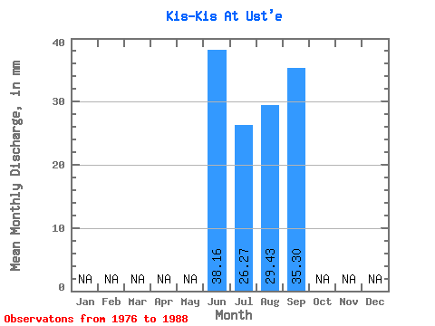
| Statistic | Jan | Feb | Mar | Apr | May | Jun | Jul | Aug | Sep | Oct | Nov | Dec | Annual |
|---|---|---|---|---|---|---|---|---|---|---|---|---|---|
| Mean | 38.17 | 26.28 | 29.43 | 35.30 | |||||||||
| Standard Deviation | 12.79 | 11.77 | 15.42 | 15.09 | |||||||||
| Min | 18.48 | 9.69 | 7.12 | 8.82 | |||||||||
| Max | 55.15 | 50.71 | 56.98 | 53.49 | |||||||||
| Coefficient of Variation | 0.34 | 0.45 | 0.52 | 0.43 |
 Return to R-Arctic Net Home Page