|
|
|||||||||||||||||
| Point ID: 7329 | Downloads | Plots | Site Data | Code: 49139 |
|
|
|||||||||||||||||
| Download | |
|---|---|
| Site Descriptor Information | Site Time Series Data |
| Link to all available data | |
| View: | Time Series | All |
| Units: | m3/s |
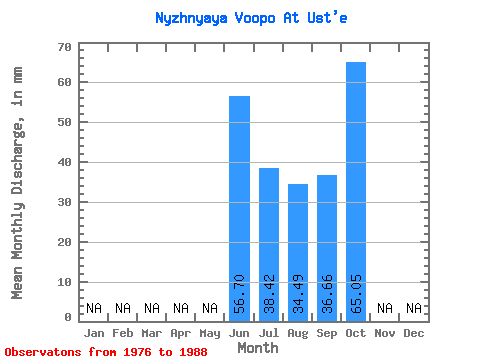
| Statistic | Jan | Feb | Mar | Apr | May | Jun | Jul | Aug | Sep | Oct | Nov | Dec | Annual |
|---|---|---|---|---|---|---|---|---|---|---|---|---|---|
| Mean | 56.70 | 38.41 | 34.49 | 36.67 | 65.04 | ||||||||
| Standard Deviation | 15.60 | 11.86 | 15.18 | 16.71 | |||||||||
| Min | 40.48 | 21.68 | 10.97 | 9.13 | 65.04 | ||||||||
| Max | 82.45 | 61.98 | 67.08 | 78.50 | 65.04 | ||||||||
| Coefficient of Variation | 0.28 | 0.31 | 0.44 | 0.46 |
 Return to R-Arctic Net Home Page