|
|
|||||||||||||||||
| Point ID: 7325 | Downloads | Plots | Site Data | Code: 49135 |
|
|
|||||||||||||||||
| Download | |
|---|---|
| Site Descriptor Information | Site Time Series Data |
| Link to all available data | |
| View: | Time Series | All |
| Units: | m3/s |
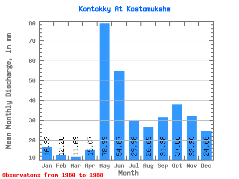
| Statistic | Jan | Feb | Mar | Apr | May | Jun | Jul | Aug | Sep | Oct | Nov | Dec | Annual |
|---|---|---|---|---|---|---|---|---|---|---|---|---|---|
| Mean | 16.31 | 12.36 | 11.71 | 15.07 | 79.00 | 54.90 | 29.98 | 26.66 | 31.36 | 37.84 | 32.31 | 24.70 | 371.05 |
| Standard Deviation | 5.55 | 4.92 | 4.00 | 6.73 | 9.39 | 13.01 | 14.95 | 15.68 | 19.46 | 15.34 | 14.92 | 11.40 | 97.00 |
| Min | 8.16 | 5.33 | 5.91 | 5.39 | 64.57 | 35.52 | 12.23 | 9.52 | 9.87 | 13.59 | 14.47 | 11.55 | 212.20 |
| Max | 23.79 | 17.34 | 18.35 | 29.60 | 94.48 | 80.92 | 52.34 | 53.70 | 61.18 | 55.05 | 54.60 | 46.22 | 478.61 |
| Coefficient of Variation | 0.34 | 0.40 | 0.34 | 0.45 | 0.12 | 0.24 | 0.50 | 0.59 | 0.62 | 0.41 | 0.46 | 0.46 | 0.26 |
 Return to R-Arctic Net Home Page