|
|
|||||||||||||||||
| Point ID: 7319 | Downloads | Plots | Site Data | Code: 49125 |
|
|
|||||||||||||||||
| Download | |
|---|---|
| Site Descriptor Information | Site Time Series Data |
| Link to all available data | |
| View: | Time Series | All |
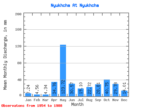
| Units: | m3/s |
| Statistic | Jan | Feb | Mar | Apr | May | Jun | Jul | Aug | Sep | Oct | Nov | Dec | Annual |
|---|---|---|---|---|---|---|---|---|---|---|---|---|---|
| Mean | 7.24 | 4.60 | 4.34 | 34.76 | 123.70 | 30.57 | 19.10 | 22.71 | 28.81 | 40.74 | 29.78 | 14.01 | 364.53 |
| Standard Deviation | 2.98 | 2.11 | 1.71 | 32.69 | 51.81 | 18.85 | 17.39 | 24.28 | 23.05 | 28.84 | 14.65 | 9.35 | 107.82 |
| Min | 2.58 | 1.73 | 1.03 | 1.88 | 39.67 | 8.14 | 3.02 | 1.55 | 2.77 | 7.24 | 4.67 | 2.20 | 210.81 |
| Max | 13.05 | 10.12 | 7.80 | 134.59 | 269.78 | 107.90 | 78.36 | 88.47 | 81.22 | 146.60 | 70.66 | 51.18 | 620.86 |
| Coefficient of Variation | 0.41 | 0.46 | 0.39 | 0.94 | 0.42 | 0.62 | 0.91 | 1.07 | 0.80 | 0.71 | 0.49 | 0.67 | 0.30 |
 Return to R-Arctic Net Home Page