|
|
|||||||||||||||||
| Point ID: 7318 | Downloads | Plots | Site Data | Code: 49124 |
|
|
|||||||||||||||||
| Download | |
|---|---|
| Site Descriptor Information | Site Time Series Data |
| Link to all available data | |
| View: | Time Series | All |
| Units: | m3/s |
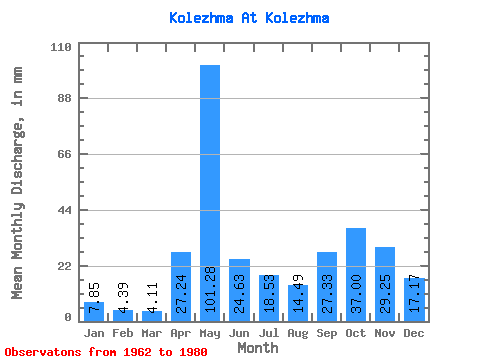
| Statistic | Jan | Feb | Mar | Apr | May | Jun | Jul | Aug | Sep | Oct | Nov | Dec | Annual |
|---|---|---|---|---|---|---|---|---|---|---|---|---|---|
| Mean | 7.85 | 4.43 | 4.11 | 27.24 | 101.27 | 24.63 | 18.52 | 14.49 | 27.33 | 37.00 | 29.25 | 17.17 | 306.54 |
| Standard Deviation | 2.93 | 2.29 | 1.65 | 19.84 | 43.50 | 13.05 | 20.37 | 14.58 | 24.55 | 23.84 | 16.97 | 9.82 | 75.63 |
| Min | 4.64 | 1.91 | 1.21 | 3.02 | 47.76 | 5.92 | 1.70 | 0.58 | 1.56 | 5.67 | 12.70 | 7.32 | 190.41 |
| Max | 13.97 | 10.74 | 8.57 | 69.55 | 186.57 | 50.11 | 76.32 | 59.36 | 91.58 | 99.53 | 81.22 | 45.08 | 443.37 |
| Coefficient of Variation | 0.37 | 0.52 | 0.40 | 0.73 | 0.43 | 0.53 | 1.10 | 1.01 | 0.90 | 0.64 | 0.58 | 0.57 | 0.25 |
 Return to R-Arctic Net Home Page