|
|
|||||||||||||||||
| Point ID: 7316 | Downloads | Plots | Site Data | Code: 49120 |
|
|
|||||||||||||||||
| Download | |
|---|---|
| Site Descriptor Information | Site Time Series Data |
| Link to all available data | |
| View: | Time Series | All |
| Units: | m3/s |
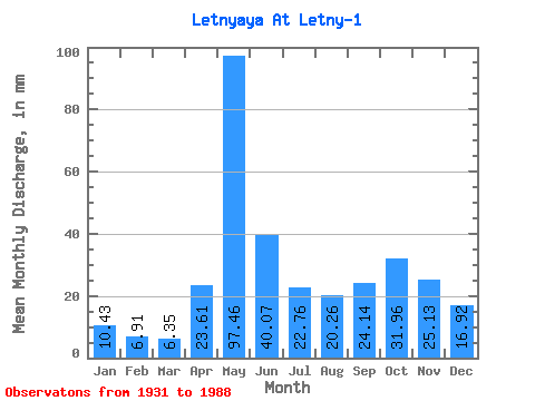
| Statistic | Jan | Feb | Mar | Apr | May | Jun | Jul | Aug | Sep | Oct | Nov | Dec | Annual |
|---|---|---|---|---|---|---|---|---|---|---|---|---|---|
| Mean | 10.43 | 6.97 | 6.35 | 23.61 | 97.45 | 40.07 | 22.75 | 20.26 | 24.14 | 31.95 | 25.13 | 16.91 | 323.06 |
| Standard Deviation | 4.42 | 2.98 | 2.50 | 21.88 | 33.21 | 18.17 | 14.73 | 16.21 | 16.62 | 18.43 | 12.75 | 7.88 | 87.60 |
| Min | 1.88 | 1.84 | 2.49 | 3.73 | 23.40 | 11.91 | 7.33 | 2.63 | 3.82 | 4.75 | 4.64 | 2.63 | 145.99 |
| Max | 20.20 | 14.68 | 11.75 | 106.86 | 180.41 | 85.94 | 74.70 | 61.55 | 65.03 | 79.87 | 51.84 | 33.31 | 515.20 |
| Coefficient of Variation | 0.42 | 0.43 | 0.39 | 0.93 | 0.34 | 0.45 | 0.65 | 0.80 | 0.69 | 0.58 | 0.51 | 0.47 | 0.27 |
 Return to R-Arctic Net Home Page