|
|
|||||||||||||||||
| Point ID: 7313 | Downloads | Plots | Site Data | Code: 49114 |
|
|
|||||||||||||||||
| Download | |
|---|---|
| Site Descriptor Information | Site Time Series Data |
| Link to all available data | |
| View: | Time Series | All |
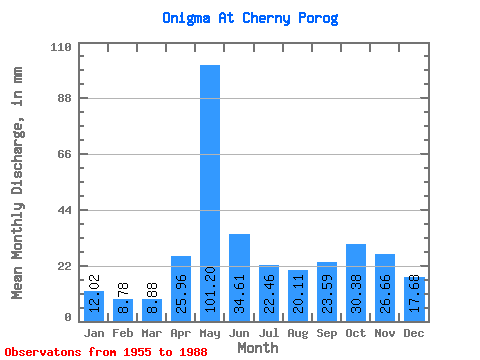
| Units: | m3/s |
| Statistic | Jan | Feb | Mar | Apr | May | Jun | Jul | Aug | Sep | Oct | Nov | Dec | Annual |
|---|---|---|---|---|---|---|---|---|---|---|---|---|---|
| Mean | 12.01 | 8.85 | 8.88 | 25.97 | 101.18 | 34.61 | 22.45 | 20.11 | 23.59 | 30.38 | 26.65 | 17.68 | 330.87 |
| Standard Deviation | 3.46 | 2.14 | 1.97 | 22.04 | 33.90 | 14.20 | 16.17 | 14.71 | 14.34 | 14.80 | 11.87 | 7.02 | 88.74 |
| Min | 7.29 | 5.66 | 5.91 | 7.65 | 34.07 | 13.52 | 8.98 | 3.45 | 4.68 | 7.67 | 7.87 | 6.98 | 203.24 |
| Max | 20.10 | 14.61 | 12.66 | 106.20 | 171.88 | 72.78 | 98.99 | 68.06 | 65.36 | 64.69 | 53.92 | 32.23 | 601.21 |
| Coefficient of Variation | 0.29 | 0.24 | 0.22 | 0.85 | 0.34 | 0.41 | 0.72 | 0.73 | 0.61 | 0.49 | 0.45 | 0.40 | 0.27 |
 Return to R-Arctic Net Home Page