|
|
|||||||||||||||||
| Point ID: 7311 | Downloads | Plots | Site Data | Code: 49110 |
|
|
|||||||||||||||||
| Download | |
|---|---|
| Site Descriptor Information | Site Time Series Data |
| Link to all available data | |
| View: | Time Series | All |
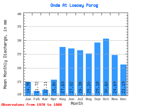
| Units: | m3/s |
| Statistic | Jan | Feb | Mar | Apr | May | Jun | Jul | Aug | Sep | Oct | Nov | Dec | Annual |
|---|---|---|---|---|---|---|---|---|---|---|---|---|---|
| Mean | 14.98 | 11.82 | 12.11 | 15.80 | 27.62 | 27.02 | 26.38 | 25.20 | 29.18 | 30.60 | 24.69 | 21.19 | 268.26 |
| Standard Deviation | 5.27 | 3.96 | 3.48 | 7.15 | 7.93 | 8.54 | 7.43 | 11.19 | 9.71 | 8.99 | 8.64 | 8.34 | 49.31 |
| Min | 4.35 | 3.91 | 4.43 | 4.00 | 16.26 | 12.73 | 14.27 | 14.11 | 12.73 | 14.98 | 9.41 | 4.30 | 190.49 |
| Max | 22.88 | 19.32 | 17.30 | 27.62 | 42.16 | 41.97 | 44.08 | 59.22 | 52.15 | 51.65 | 44.20 | 34.83 | 349.96 |
| Coefficient of Variation | 0.35 | 0.33 | 0.29 | 0.45 | 0.29 | 0.32 | 0.28 | 0.44 | 0.33 | 0.29 | 0.35 | 0.39 | 0.18 |
 Return to R-Arctic Net Home Page