|
|
|||||||||||||||||
| Point ID: 7309 | Downloads | Plots | Site Data | Code: 49103 |
|
|
|||||||||||||||||
| Download | |
|---|---|
| Site Descriptor Information | Site Time Series Data |
| Link to all available data | |
| View: | Time Series | All |
| Units: | m3/s |
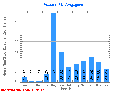
| Statistic | Jan | Feb | Mar | Apr | May | Jun | Jul | Aug | Sep | Oct | Nov | Dec | Annual |
|---|---|---|---|---|---|---|---|---|---|---|---|---|---|
| Mean | 15.07 | 11.31 | 11.23 | 18.20 | 77.60 | 39.81 | 25.15 | 28.18 | 30.92 | 34.51 | 29.88 | 23.24 | 343.88 |
| Standard Deviation | 3.38 | 2.79 | 2.27 | 10.23 | 23.74 | 13.89 | 12.56 | 21.56 | 16.59 | 14.31 | 13.21 | 8.71 | 77.74 |
| Min | 9.13 | 6.74 | 7.90 | 8.38 | 41.47 | 23.27 | 13.65 | 10.18 | 10.77 | 15.69 | 12.99 | 10.38 | 219.58 |
| Max | 20.30 | 17.32 | 16.70 | 44.73 | 121.81 | 78.46 | 46.22 | 91.28 | 70.93 | 59.90 | 61.45 | 39.31 | 486.49 |
| Coefficient of Variation | 0.22 | 0.25 | 0.20 | 0.56 | 0.31 | 0.35 | 0.50 | 0.77 | 0.54 | 0.41 | 0.44 | 0.38 | 0.23 |
 Return to R-Arctic Net Home Page