|
|
|||||||||||||||||
| Point ID: 7304 | Downloads | Plots | Site Data | Code: 49093 |
|
|
|||||||||||||||||
| Download | |
|---|---|
| Site Descriptor Information | Site Time Series Data |
| Link to all available data | |
| View: | Time Series | All |
| Units: | m3/s |
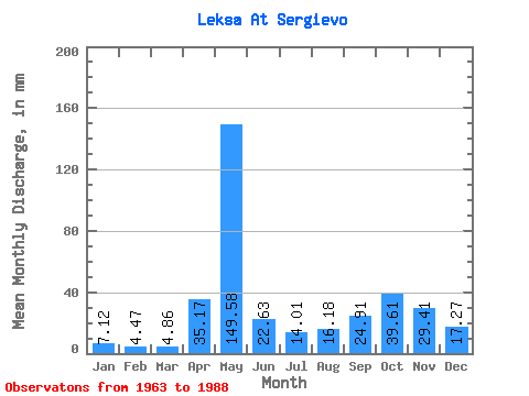
| Statistic | Jan | Feb | Mar | Apr | May | Jun | Jul | Aug | Sep | Oct | Nov | Dec | Annual |
|---|---|---|---|---|---|---|---|---|---|---|---|---|---|
| Mean | 7.12 | 4.51 | 4.86 | 35.17 | 149.56 | 22.63 | 14.00 | 16.18 | 24.91 | 39.60 | 29.41 | 17.27 | 362.75 |
| Standard Deviation | 3.98 | 2.55 | 2.35 | 33.45 | 53.39 | 12.76 | 8.78 | 14.92 | 16.40 | 21.82 | 15.70 | 16.93 | 81.32 |
| Min | 2.08 | 1.37 | 0.56 | 3.19 | 53.04 | 6.94 | 5.09 | 2.72 | 4.42 | 10.76 | 4.31 | 4.22 | 258.63 |
| Max | 14.11 | 11.22 | 10.93 | 141.08 | 233.10 | 68.30 | 45.23 | 64.20 | 73.34 | 100.06 | 71.10 | 76.93 | 556.22 |
| Coefficient of Variation | 0.56 | 0.56 | 0.48 | 0.95 | 0.36 | 0.56 | 0.63 | 0.92 | 0.66 | 0.55 | 0.53 | 0.98 | 0.22 |
 Return to R-Arctic Net Home Page