|
|
|||||||||||||||||
| Point ID: 7298 | Downloads | Plots | Site Data | Code: 49070 |
|
|
|||||||||||||||||
| Download | |
|---|---|
| Site Descriptor Information | Site Time Series Data |
| Link to all available data | |
| View: | Time Series | All |
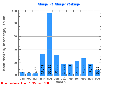
| Units: | m3/s |
| Statistic | Jan | Feb | Mar | Apr | May | Jun | Jul | Aug | Sep | Oct | Nov | Dec | Annual |
|---|---|---|---|---|---|---|---|---|---|---|---|---|---|
| Mean | 5.78 | 4.02 | 3.90 | 33.06 | 95.11 | 31.68 | 17.67 | 17.31 | 22.45 | 26.59 | 18.05 | 9.19 | 277.78 |
| Standard Deviation | 3.07 | 1.93 | 1.63 | 29.65 | 38.61 | 20.76 | 13.79 | 16.63 | 16.60 | 16.20 | 10.29 | 4.97 | 80.31 |
| Min | 1.66 | 1.25 | 1.38 | 2.11 | 20.96 | 8.66 | 3.50 | 2.06 | 2.00 | 2.41 | 1.78 | 1.52 | 127.19 |
| Max | 18.87 | 11.34 | 10.64 | 130.71 | 192.10 | 86.03 | 63.94 | 87.16 | 75.76 | 72.54 | 43.29 | 27.58 | 543.26 |
| Coefficient of Variation | 0.53 | 0.48 | 0.42 | 0.90 | 0.41 | 0.66 | 0.78 | 0.96 | 0.74 | 0.61 | 0.57 | 0.54 | 0.29 |
 Return to R-Arctic Net Home Page