|
|
|||||||||||||||||
| Point ID: 7295 | Downloads | Plots | Site Data | Code: 49066 |
|
|
|||||||||||||||||
| Download | |
|---|---|
| Site Descriptor Information | Site Time Series Data |
| Link to all available data | |
| View: | Time Series | All |
| Units: | m3/s |
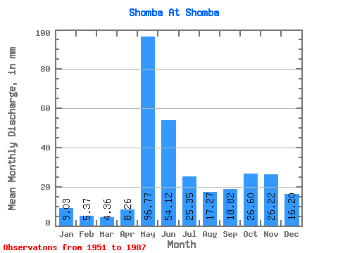
| Statistic | Jan | Feb | Mar | Apr | May | Jun | Jul | Aug | Sep | Oct | Nov | Dec | Annual |
|---|---|---|---|---|---|---|---|---|---|---|---|---|---|
| Mean | 9.02 | 5.42 | 4.36 | 8.26 | 96.76 | 54.12 | 25.35 | 17.27 | 18.82 | 26.59 | 26.22 | 16.20 | 305.73 |
| Standard Deviation | 4.40 | 2.14 | 1.86 | 7.97 | 32.45 | 24.89 | 23.64 | 15.38 | 16.07 | 14.19 | 13.80 | 8.08 | 84.15 |
| Min | 3.28 | 1.90 | 1.22 | 1.69 | 38.48 | 17.06 | 5.98 | 2.55 | 1.96 | 3.30 | 3.80 | 2.63 | 105.79 |
| Max | 23.04 | 11.85 | 9.07 | 34.22 | 160.42 | 127.33 | 133.64 | 64.48 | 59.64 | 62.14 | 64.17 | 35.10 | 499.67 |
| Coefficient of Variation | 0.49 | 0.40 | 0.43 | 0.96 | 0.34 | 0.46 | 0.93 | 0.89 | 0.85 | 0.53 | 0.53 | 0.50 | 0.28 |
 Return to R-Arctic Net Home Page