|
|
|||||||||||||||||
| Point ID: 7294 | Downloads | Plots | Site Data | Code: 49063 |
|
|
|||||||||||||||||
| Download | |
|---|---|
| Site Descriptor Information | Site Time Series Data |
| Link to all available data | |
| View: | Time Series | All |
| Units: | m3/s |
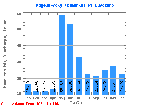
| Statistic | Jan | Feb | Mar | Apr | May | Jun | Jul | Aug | Sep | Oct | Nov | Dec | Annual |
|---|---|---|---|---|---|---|---|---|---|---|---|---|---|
| Mean | 16.49 | 12.57 | 12.27 | 13.65 | 58.68 | 52.96 | 32.63 | 22.71 | 21.14 | 25.21 | 27.57 | 22.70 | 315.30 |
| Standard Deviation | 5.03 | 3.48 | 2.35 | 5.16 | 20.85 | 18.69 | 14.35 | 12.58 | 11.40 | 12.94 | 13.43 | 9.35 | 82.07 |
| Min | 9.14 | 6.24 | 7.90 | 7.21 | 17.04 | 22.30 | 15.07 | 7.30 | 5.98 | 5.68 | 6.76 | 8.26 | 152.81 |
| Max | 27.80 | 21.76 | 17.71 | 33.40 | 97.73 | 93.91 | 68.80 | 67.39 | 59.76 | 60.69 | 59.08 | 51.16 | 559.54 |
| Coefficient of Variation | 0.30 | 0.28 | 0.19 | 0.38 | 0.35 | 0.35 | 0.44 | 0.55 | 0.54 | 0.51 | 0.49 | 0.41 | 0.26 |
 Return to R-Arctic Net Home Page