|
|
|||||||||||||||||
| Point ID: 7285 | Downloads | Plots | Site Data | Code: 49047 |
|
|
|||||||||||||||||
| Download | |
|---|---|
| Site Descriptor Information | Site Time Series Data |
| Link to all available data | |
| View: | Time Series | All |
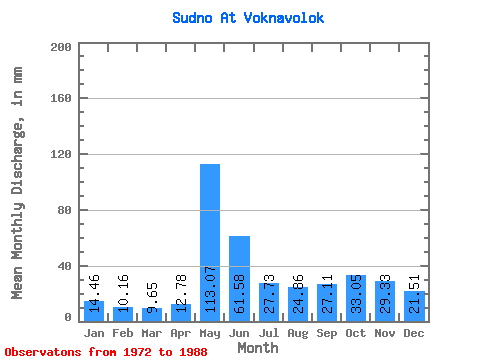
| Units: | m3/s |
| Statistic | Jan | Feb | Mar | Apr | May | Jun | Jul | Aug | Sep | Oct | Nov | Dec | Annual |
|---|---|---|---|---|---|---|---|---|---|---|---|---|---|
| Mean | 14.45 | 10.24 | 9.65 | 12.78 | 113.06 | 61.58 | 27.73 | 24.86 | 27.11 | 33.05 | 29.33 | 21.51 | 383.68 |
| Standard Deviation | 3.80 | 2.67 | 2.69 | 6.57 | 37.60 | 20.48 | 15.28 | 16.50 | 15.31 | 14.84 | 13.53 | 8.25 | 76.39 |
| Min | 9.58 | 6.84 | 6.07 | 6.26 | 47.33 | 31.95 | 10.62 | 6.63 | 6.39 | 14.89 | 14.99 | 13.34 | 252.48 |
| Max | 22.39 | 17.12 | 17.48 | 31.51 | 189.31 | 104.13 | 60.26 | 61.64 | 58.54 | 60.49 | 68.15 | 43.63 | 515.46 |
| Coefficient of Variation | 0.26 | 0.26 | 0.28 | 0.51 | 0.33 | 0.33 | 0.55 | 0.66 | 0.56 | 0.45 | 0.46 | 0.38 | 0.20 |
 Return to R-Arctic Net Home Page