|
|
|||||||||||||||||
| Point ID: 7273 | Downloads | Plots | Site Data | Code: 49026 |
|
|
|||||||||||||||||
| Download | |
|---|---|
| Site Descriptor Information | Site Time Series Data |
| Link to all available data | |
| View: | Time Series | All |
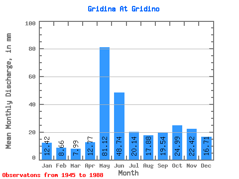
| Units: | m3/s |
| Statistic | Jan | Feb | Mar | Apr | May | Jun | Jul | Aug | Sep | Oct | Nov | Dec | Annual |
|---|---|---|---|---|---|---|---|---|---|---|---|---|---|
| Mean | 12.42 | 8.73 | 7.99 | 12.77 | 81.11 | 48.75 | 20.13 | 17.87 | 19.54 | 24.99 | 22.42 | 16.71 | 291.51 |
| Standard Deviation | 4.73 | 3.07 | 3.01 | 10.88 | 27.89 | 24.62 | 12.37 | 17.05 | 15.27 | 15.14 | 12.44 | 8.00 | 79.47 |
| Min | 3.27 | 2.94 | 1.98 | 1.49 | 24.95 | 17.33 | 5.16 | 2.23 | 1.82 | 2.98 | 3.17 | 3.27 | 122.78 |
| Max | 22.07 | 15.05 | 18.35 | 55.68 | 159.69 | 123.36 | 67.94 | 75.88 | 66.72 | 57.53 | 56.64 | 33.57 | 512.46 |
| Coefficient of Variation | 0.38 | 0.35 | 0.38 | 0.85 | 0.34 | 0.51 | 0.61 | 0.95 | 0.78 | 0.61 | 0.56 | 0.48 | 0.27 |
 Return to R-Arctic Net Home Page