|
|
|||||||||||||||||
| Point ID: 7272 | Downloads | Plots | Site Data | Code: 49025 |
|
|
|||||||||||||||||
| Download | |
|---|---|
| Site Descriptor Information | Site Time Series Data |
| Link to all available data | |
| View: | Time Series | All |
| Units: | m3/s |
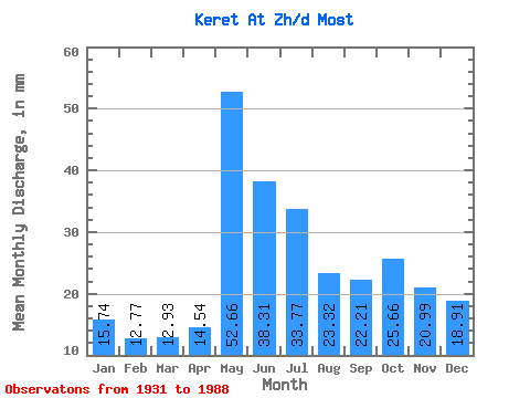
| Statistic | Jan | Feb | Mar | Apr | May | Jun | Jul | Aug | Sep | Oct | Nov | Dec | Annual |
|---|---|---|---|---|---|---|---|---|---|---|---|---|---|
| Mean | 15.74 | 12.88 | 12.93 | 14.54 | 52.66 | 38.31 | 33.76 | 23.32 | 22.21 | 25.65 | 20.99 | 18.91 | 288.13 |
| Standard Deviation | 4.85 | 3.50 | 3.15 | 6.47 | 16.43 | 13.25 | 45.88 | 9.86 | 9.57 | 11.75 | 8.79 | 7.66 | 89.10 |
| Min | 5.69 | 4.95 | 4.73 | 7.10 | 17.36 | 17.82 | 10.88 | 8.14 | 6.37 | 6.09 | 4.34 | 5.74 | 120.83 |
| Max | 24.16 | 18.20 | 18.31 | 40.80 | 101.47 | 84.14 | 369.27 | 56.59 | 52.14 | 77.93 | 46.98 | 37.14 | 704.14 |
| Coefficient of Variation | 0.31 | 0.27 | 0.24 | 0.45 | 0.31 | 0.35 | 1.36 | 0.42 | 0.43 | 0.46 | 0.42 | 0.41 | 0.31 |
 Return to R-Arctic Net Home Page