|
|
|||||||||||||||||
| Point ID: 7270 | Downloads | Plots | Site Data | Code: 49014 |
|
|
|||||||||||||||||
| Download | |
|---|---|
| Site Descriptor Information | Site Time Series Data |
| Link to all available data | |
| View: | Time Series | All |
| Units: | m3/s |
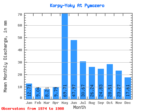
| Statistic | Jan | Feb | Mar | Apr | May | Jun | Jul | Aug | Sep | Oct | Nov | Dec | Annual |
|---|---|---|---|---|---|---|---|---|---|---|---|---|---|
| Mean | 12.71 | 9.12 | 8.21 | 9.79 | 69.70 | 47.97 | 30.67 | 26.24 | 24.83 | 28.51 | 23.27 | 17.61 | 301.55 |
| Standard Deviation | 4.75 | 3.30 | 2.14 | 5.21 | 25.63 | 17.19 | 13.31 | 14.98 | 13.52 | 13.71 | 10.65 | 6.17 | 70.70 |
| Min | 5.92 | 4.83 | 4.81 | 6.33 | 33.44 | 22.34 | 9.63 | 6.29 | 3.94 | 6.79 | 5.02 | 6.79 | 154.41 |
| Max | 23.94 | 18.44 | 13.82 | 25.68 | 124.64 | 80.75 | 58.87 | 54.67 | 47.54 | 57.76 | 49.57 | 26.04 | 396.08 |
| Coefficient of Variation | 0.37 | 0.36 | 0.26 | 0.53 | 0.37 | 0.36 | 0.43 | 0.57 | 0.54 | 0.48 | 0.46 | 0.35 | 0.23 |
 Return to R-Arctic Net Home Page