|
|
|||||||||||||||||
| Point ID: 727 | Downloads | Plots | Site Data | Code: 07DD002 |
|
|
|||||||||||||||||
| Download | |
|---|---|
| Site Descriptor Information | Site Time Series Data |
| Link to all available data | |
| View: | Time Series | All |
| Units: | m3/s |
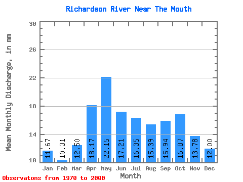
| Statistic | Jan | Feb | Mar | Apr | May | Jun | Jul | Aug | Sep | Oct | Nov | Dec | Annual |
|---|---|---|---|---|---|---|---|---|---|---|---|---|---|
| Mean | 11.66 | 10.39 | 12.50 | 18.17 | 22.15 | 17.21 | 16.35 | 15.39 | 15.94 | 16.86 | 13.78 | 12.00 | 178.74 |
| Standard Deviation | 1.11 | 1.01 | 1.49 | 4.08 | 3.81 | 2.50 | 2.93 | 2.56 | 3.08 | 3.91 | 2.11 | 1.57 | 17.36 |
| Min | 8.87 | 8.16 | 9.50 | 11.14 | 14.58 | 12.48 | 12.79 | 11.21 | 10.18 | 11.61 | 10.37 | 9.13 | 155.86 |
| Max | 13.49 | 12.11 | 16.17 | 29.09 | 28.66 | 23.23 | 23.41 | 21.62 | 22.94 | 28.57 | 17.09 | 14.78 | 207.09 |
| Coefficient of Variation | 0.10 | 0.10 | 0.12 | 0.23 | 0.17 | 0.14 | 0.18 | 0.17 | 0.19 | 0.23 | 0.15 | 0.13 | 0.10 |
 Return to R-Arctic Net Home Page