|
|
|||||||||||||||||
| Point ID: 7250 | Downloads | Plots | Site Data | Code: 12528 |
|
|
|||||||||||||||||
| Download | |
|---|---|
| Site Descriptor Information | Site Time Series Data |
| Link to all available data | |
| View: | Time Series | All |
| Units: | m3/s |
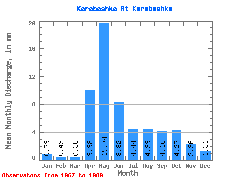
| Statistic | Jan | Feb | Mar | Apr | May | Jun | Jul | Aug | Sep | Oct | Nov | Dec | Annual |
|---|---|---|---|---|---|---|---|---|---|---|---|---|---|
| Mean | 0.79 | 0.43 | 0.38 | 9.98 | 19.74 | 8.32 | 4.44 | 4.39 | 4.16 | 4.27 | 2.37 | 1.31 | 63.13 |
| Standard Deviation | 0.66 | 0.42 | 0.32 | 5.71 | 11.84 | 5.20 | 3.71 | 5.06 | 4.46 | 4.21 | 2.18 | 1.08 | 30.67 |
| Min | 0.02 | 0.01 | 0.00 | 0.48 | 2.48 | 1.68 | 0.54 | 0.62 | 0.64 | 0.70 | 0.38 | 0.08 | 13.86 |
| Max | 2.31 | 1.43 | 1.12 | 19.28 | 45.05 | 17.96 | 11.78 | 16.45 | 15.40 | 15.41 | 8.44 | 3.43 | 129.27 |
| Coefficient of Variation | 0.84 | 0.96 | 0.85 | 0.57 | 0.60 | 0.62 | 0.84 | 1.15 | 1.07 | 0.99 | 0.92 | 0.82 | 0.49 |
 Return to R-Arctic Net Home Page