|
|
|||||||||||||||||
| Point ID: 7247 | Downloads | Plots | Site Data | Code: 12519 |
|
|
|||||||||||||||||
| Download | |
|---|---|
| Site Descriptor Information | Site Time Series Data |
| Link to all available data | |
| View: | Time Series | All |
| Units: | m3/s |
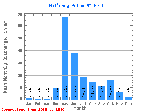
| Statistic | Jan | Feb | Mar | Apr | May | Jun | Jul | Aug | Sep | Oct | Nov | Dec | Annual |
|---|---|---|---|---|---|---|---|---|---|---|---|---|---|
| Mean | 1.62 | 1.02 | 1.10 | 9.33 | 67.11 | 37.98 | 18.40 | 14.25 | 11.26 | 15.87 | 6.17 | 2.56 | 175.15 |
| Standard Deviation | 0.63 | 0.38 | 0.35 | 11.94 | 30.61 | 26.19 | 19.76 | 13.70 | 7.81 | 11.47 | 4.39 | 1.51 | 56.50 |
| Min | 0.36 | 0.23 | 0.36 | 1.34 | 14.94 | 4.49 | 4.01 | 2.62 | 2.45 | 2.57 | 1.75 | 0.66 | 84.56 |
| Max | 2.57 | 1.66 | 1.60 | 52.05 | 138.33 | 98.54 | 65.29 | 54.61 | 33.15 | 41.17 | 16.28 | 5.64 | 270.56 |
| Coefficient of Variation | 0.39 | 0.37 | 0.32 | 1.28 | 0.46 | 0.69 | 1.07 | 0.96 | 0.69 | 0.72 | 0.71 | 0.59 | 0.32 |
 Return to R-Arctic Net Home Page