|
|
|||||||||||||||||
| Point ID: 7245 | Downloads | Plots | Site Data | Code: 12514 |
|
|
|||||||||||||||||
| Download | |
|---|---|
| Site Descriptor Information | Site Time Series Data |
| Link to all available data | |
| View: | Time Series | All |
| Units: | m3/s |
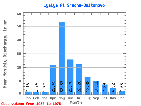
| Statistic | Jan | Feb | Mar | Apr | May | Jun | Jul | Aug | Sep | Oct | Nov | Dec | Annual |
|---|---|---|---|---|---|---|---|---|---|---|---|---|---|
| Mean | 2.16 | 1.76 | 1.92 | 21.49 | 52.88 | 25.70 | 22.28 | 12.88 | 10.12 | 7.39 | 4.52 | 2.65 | 168.37 |
| Standard Deviation | 0.81 | 0.68 | 0.80 | 14.22 | 28.90 | 15.15 | 24.41 | 13.47 | 13.85 | 4.69 | 2.26 | 1.19 | 70.64 |
| Min | 0.46 | 0.28 | 0.23 | 3.62 | 11.57 | 5.73 | 4.16 | 2.14 | 1.77 | 1.53 | 1.54 | 0.93 | 70.63 |
| Max | 4.14 | 3.27 | 3.83 | 55.63 | 120.11 | 85.77 | 104.98 | 53.20 | 79.05 | 22.51 | 13.09 | 5.44 | 379.80 |
| Coefficient of Variation | 0.38 | 0.39 | 0.42 | 0.66 | 0.55 | 0.59 | 1.10 | 1.05 | 1.37 | 0.64 | 0.50 | 0.45 | 0.42 |
 Return to R-Arctic Net Home Page