|
|
|||||||||||||||||
| Point ID: 7241 | Downloads | Plots | Site Data | Code: 12434 |
|
|
|||||||||||||||||
| Download | |
|---|---|
| Site Descriptor Information | Site Time Series Data |
| Link to all available data | |
| View: | Time Series | All |
| Units: | m3/s |
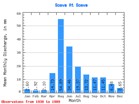
| Statistic | Jan | Feb | Mar | Apr | May | Jun | Jul | Aug | Sep | Oct | Nov | Dec | Annual |
|---|---|---|---|---|---|---|---|---|---|---|---|---|---|
| Mean | 2.60 | 1.94 | 2.10 | 14.73 | 54.88 | 34.46 | 19.37 | 13.72 | 11.47 | 11.45 | 6.48 | 3.65 | 176.05 |
| Standard Deviation | 1.05 | 0.73 | 0.78 | 10.31 | 26.67 | 18.14 | 15.02 | 12.09 | 8.61 | 8.99 | 3.77 | 1.69 | 62.70 |
| Min | 0.69 | 0.54 | 0.64 | 1.89 | 13.94 | 8.55 | 3.39 | 3.36 | 2.16 | 2.68 | 2.04 | 1.36 | 77.98 |
| Max | 5.16 | 3.34 | 3.68 | 49.96 | 151.47 | 76.00 | 75.98 | 53.92 | 37.53 | 41.56 | 18.53 | 8.19 | 306.32 |
| Coefficient of Variation | 0.40 | 0.38 | 0.37 | 0.70 | 0.49 | 0.53 | 0.78 | 0.88 | 0.75 | 0.79 | 0.58 | 0.46 | 0.36 |
 Return to R-Arctic Net Home Page