|
|
|||||||||||||||||
| Point ID: 7235 | Downloads | Plots | Site Data | Code: 12415 |
|
|
|||||||||||||||||
| Download | |
|---|---|
| Site Descriptor Information | Site Time Series Data |
| Link to all available data | |
| View: | Time Series | All |
| Units: | m3/s |
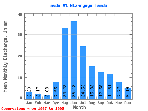
| Statistic | Jan | Feb | Mar | Apr | May | Jun | Jul | Aug | Sep | Oct | Nov | Dec | Annual |
|---|---|---|---|---|---|---|---|---|---|---|---|---|---|
| Mean | 3.20 | 2.19 | 2.03 | 7.95 | 33.21 | 36.18 | 24.53 | 15.32 | 12.58 | 11.81 | 7.77 | 5.19 | 156.45 |
| Standard Deviation | 1.35 | 0.91 | 0.89 | 5.23 | 11.23 | 13.82 | 14.02 | 10.75 | 8.19 | 8.90 | 5.49 | 3.34 | 54.83 |
| Min | 1.12 | 0.74 | 0.98 | 2.44 | 12.75 | 12.58 | 3.61 | 4.14 | 3.37 | 2.94 | 1.92 | 1.69 | 82.67 |
| Max | 6.81 | 5.04 | 5.35 | 26.04 | 48.52 | 62.92 | 54.43 | 45.41 | 33.42 | 39.19 | 23.45 | 15.89 | 280.81 |
| Coefficient of Variation | 0.42 | 0.41 | 0.44 | 0.66 | 0.34 | 0.38 | 0.57 | 0.70 | 0.65 | 0.75 | 0.71 | 0.64 | 0.35 |
 Return to R-Arctic Net Home Page