|
|
|||||||||||||||||
| Point ID: 7232 | Downloads | Plots | Site Data | Code: 12407 |
|
|
|||||||||||||||||
| Download | |
|---|---|
| Site Descriptor Information | Site Time Series Data |
| Link to all available data | |
| View: | Time Series | All |
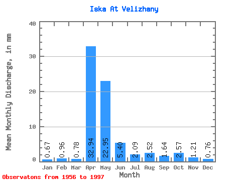
| Units: | m3/s |
| Statistic | Jan | Feb | Mar | Apr | May | Jun | Jul | Aug | Sep | Oct | Nov | Dec | Annual |
|---|---|---|---|---|---|---|---|---|---|---|---|---|---|
| Mean | 0.67 | 0.96 | 0.78 | 32.94 | 22.94 | 5.40 | 2.08 | 2.52 | 1.64 | 2.57 | 1.21 | 0.76 | 75.33 |
| Standard Deviation | 0.54 | 3.10 | 0.81 | 27.69 | 24.77 | 5.69 | 2.42 | 5.24 | 2.16 | 4.53 | 1.02 | 0.51 | 52.23 |
| Min | 0.12 | 0.14 | 0.15 | 3.88 | 2.04 | 0.26 | 0.21 | 0.21 | 0.26 | 0.17 | 0.41 | 0.23 | 15.57 |
| Max | 3.26 | 19.77 | 4.10 | 106.87 | 104.43 | 23.02 | 14.99 | 23.58 | 10.43 | 26.93 | 5.21 | 3.20 | 227.62 |
| Coefficient of Variation | 0.81 | 3.22 | 1.03 | 0.84 | 1.08 | 1.05 | 1.16 | 2.08 | 1.32 | 1.76 | 0.84 | 0.67 | 0.69 |
 Return to R-Arctic Net Home Page