|
|
|||||||||||||||||
| Point ID: 723 | Downloads | Plots | Site Data | Code: 07DB005 |
|
|
|||||||||||||||||
| Download | |
|---|---|
| Site Descriptor Information | Site Time Series Data |
| Link to all available data | |
| View: | Time Series | All |
| Units: | m3/s |
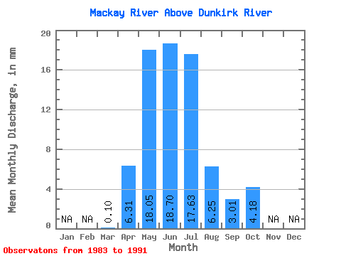
| Statistic | Jan | Feb | Mar | Apr | May | Jun | Jul | Aug | Sep | Oct | Nov | Dec | Annual |
|---|---|---|---|---|---|---|---|---|---|---|---|---|---|
| Mean | 0.10 | 6.31 | 18.04 | 18.70 | 17.62 | 6.25 | 3.01 | 4.18 | |||||
| Standard Deviation | 0.08 | 4.03 | 20.16 | 17.72 | 25.86 | 8.13 | 3.36 | 6.18 | |||||
| Min | 0.00 | 1.95 | 0.73 | 2.31 | 0.25 | 0.04 | 0.35 | 0.27 | |||||
| Max | 0.27 | 12.22 | 59.13 | 52.35 | 64.43 | 24.71 | 10.03 | 18.80 | |||||
| Coefficient of Variation | 0.82 | 0.64 | 1.12 | 0.95 | 1.47 | 1.30 | 1.12 | 1.48 |
 Return to R-Arctic Net Home Page