|
|
|||||||||||||||||
| Point ID: 7226 | Downloads | Plots | Site Data | Code: 12375 |
|
|
|||||||||||||||||
| Download | |
|---|---|
| Site Descriptor Information | Site Time Series Data |
| Link to all available data | |
| View: | Time Series | All |
| Units: | m3/s |
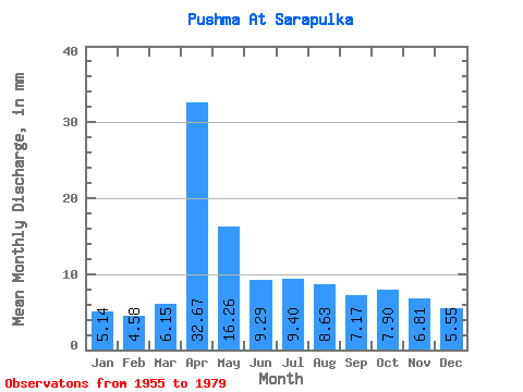
| Statistic | Jan | Feb | Mar | Apr | May | Jun | Jul | Aug | Sep | Oct | Nov | Dec | Annual |
|---|---|---|---|---|---|---|---|---|---|---|---|---|---|
| Mean | 5.14 | 4.62 | 6.15 | 32.67 | 16.26 | 9.28 | 9.40 | 8.63 | 7.17 | 7.90 | 6.82 | 5.55 | 117.66 |
| Standard Deviation | 1.50 | 1.19 | 2.21 | 13.40 | 9.68 | 3.40 | 6.22 | 6.37 | 2.09 | 2.38 | 2.31 | 1.56 | 27.47 |
| Min | 1.66 | 2.35 | 3.19 | 11.18 | 6.58 | 3.40 | 4.16 | 3.15 | 4.34 | 4.93 | 3.91 | 2.54 | 81.52 |
| Max | 8.32 | 7.62 | 13.01 | 59.42 | 56.15 | 17.01 | 29.57 | 27.75 | 12.47 | 13.77 | 12.04 | 8.72 | 177.32 |
| Coefficient of Variation | 0.29 | 0.26 | 0.36 | 0.41 | 0.60 | 0.37 | 0.66 | 0.74 | 0.29 | 0.30 | 0.34 | 0.28 | 0.23 |
 Return to R-Arctic Net Home Page