|
|
|||||||||||||||||
| Point ID: 7217 | Downloads | Plots | Site Data | Code: 12305 |
|
|
|||||||||||||||||
| Download | |
|---|---|
| Site Descriptor Information | Site Time Series Data |
| Link to all available data | |
| View: | Time Series | All |
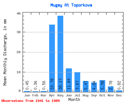
| Units: | m3/s |
| Statistic | Jan | Feb | Mar | Apr | May | Jun | Jul | Aug | Sep | Oct | Nov | Dec | Annual |
|---|---|---|---|---|---|---|---|---|---|---|---|---|---|
| Mean | 0.45 | 0.36 | 0.56 | 33.78 | 38.17 | 11.84 | 9.87 | 5.47 | 4.84 | 5.98 | 2.78 | 0.82 | 117.10 |
| Standard Deviation | 0.38 | 0.33 | 0.62 | 25.32 | 28.96 | 9.38 | 17.86 | 8.42 | 7.15 | 7.74 | 3.79 | 0.71 | 63.61 |
| Min | 0.00 | 0.03 | 0.06 | 1.28 | 3.62 | 1.59 | 0.27 | 0.15 | 0.22 | 0.23 | 0.01 | 0.13 | 21.34 |
| Max | 1.36 | 1.69 | 2.83 | 100.16 | 147.86 | 39.62 | 74.98 | 34.81 | 35.18 | 33.48 | 19.25 | 2.72 | 233.94 |
| Coefficient of Variation | 0.83 | 0.92 | 1.11 | 0.75 | 0.76 | 0.79 | 1.81 | 1.54 | 1.48 | 1.29 | 1.36 | 0.86 | 0.54 |
 Return to R-Arctic Net Home Page