|
|
|||||||||||||||||
| Point ID: 7209 | Downloads | Plots | Site Data | Code: 12230 |
|
|
|||||||||||||||||
| Download | |
|---|---|
| Site Descriptor Information | Site Time Series Data |
| Link to all available data | |
| View: | Time Series | All |
| Units: | m3/s |
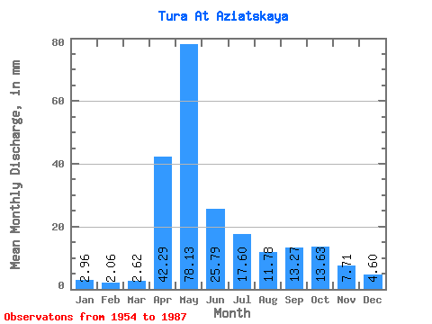
| Statistic | Jan | Feb | Mar | Apr | May | Jun | Jul | Aug | Sep | Oct | Nov | Dec | Annual |
|---|---|---|---|---|---|---|---|---|---|---|---|---|---|
| Mean | 2.96 | 2.08 | 2.63 | 42.29 | 78.12 | 25.79 | 17.59 | 11.78 | 13.27 | 13.63 | 7.71 | 4.60 | 225.65 |
| Standard Deviation | 1.17 | 0.81 | 1.11 | 26.71 | 48.19 | 22.74 | 16.77 | 9.82 | 14.50 | 13.91 | 7.22 | 2.48 | 80.10 |
| Min | 0.30 | 0.18 | 0.31 | 3.82 | 14.16 | 6.05 | 2.52 | 2.08 | 1.91 | 1.87 | 1.70 | 1.43 | 91.19 |
| Max | 6.04 | 3.80 | 5.16 | 120.04 | 186.58 | 118.98 | 70.79 | 36.33 | 63.84 | 52.13 | 37.07 | 12.18 | 403.34 |
| Coefficient of Variation | 0.39 | 0.39 | 0.42 | 0.63 | 0.62 | 0.88 | 0.95 | 0.83 | 1.09 | 1.02 | 0.94 | 0.54 | 0.35 |
 Return to R-Arctic Net Home Page