|
|
|||||||||||||||||
| Point ID: 7202 | Downloads | Plots | Site Data | Other Close Sites | Code: 12202 |
|
|
|||||||||||||||||
| Download | |
|---|---|
| Site Descriptor Information | Site Time Series Data |
| Link to all available data | |
| View: | Time Series | All |
| Units: | m3/s |
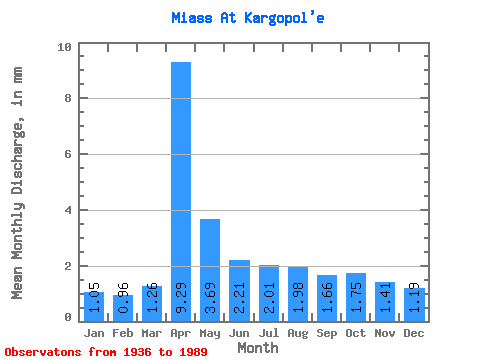
| Statistic | Jan | Feb | Mar | Apr | May | Jun | Jul | Aug | Sep | Oct | Nov | Dec | Annual |
|---|---|---|---|---|---|---|---|---|---|---|---|---|---|
| Mean | 0.92 | 0.85 | 1.11 | 8.16 | 3.24 | 1.94 | 1.77 | 1.74 | 1.46 | 1.53 | 1.24 | 1.04 | 25.06 |
| Standard Deviation | 0.33 | 0.33 | 0.47 | 5.20 | 2.47 | 1.01 | 0.85 | 1.07 | 0.64 | 1.07 | 0.48 | 0.45 | 10.86 |
| Min | 0.28 | 0.28 | 0.39 | 1.89 | 1.03 | 0.67 | 0.73 | 0.70 | 0.62 | 0.59 | 0.57 | 0.30 | 9.32 |
| Max | 1.84 | 1.61 | 2.56 | 19.98 | 13.02 | 5.08 | 4.50 | 5.22 | 4.14 | 7.72 | 2.80 | 2.84 | 55.60 |
| Coefficient of Variation | 0.35 | 0.38 | 0.42 | 0.64 | 0.76 | 0.52 | 0.48 | 0.62 | 0.44 | 0.70 | 0.39 | 0.43 | 0.43 |
| Other Close Sites | ||||||
|---|---|---|---|---|---|---|
| PointID | Latitude | Longitude | Drainage Area | Source | Name | |
| 7184 | "Iset' At Mekhonskoye" | 56.15 | -1592923 | SHI | 204.00 | |
 Return to R-Arctic Net Home Page