|
|
|||||||||||||||||
| Point ID: 7201 | Downloads | Plots | Site Data | Code: 12201 |
|
|
|||||||||||||||||
| Download | |
|---|---|
| Site Descriptor Information | Site Time Series Data |
| Link to all available data | |
| View: | Time Series | All |
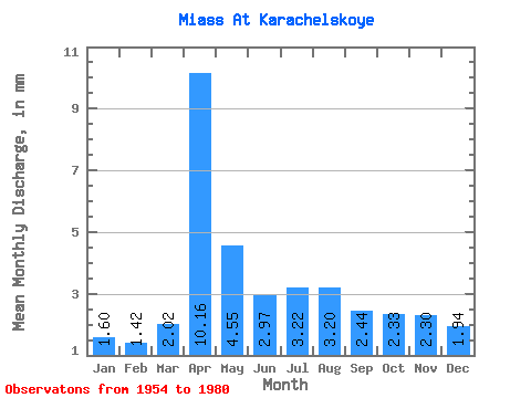
| Units: | m3/s |
| Statistic | Jan | Feb | Mar | Apr | May | Jun | Jul | Aug | Sep | Oct | Nov | Dec | Annual |
|---|---|---|---|---|---|---|---|---|---|---|---|---|---|
| Mean | 1.31 | 1.17 | 1.65 | 8.29 | 3.71 | 2.42 | 2.62 | 2.61 | 1.99 | 1.90 | 1.88 | 1.58 | 31.87 |
| Standard Deviation | 0.48 | 0.42 | 0.76 | 5.16 | 2.83 | 1.34 | 1.62 | 1.82 | 1.08 | 0.63 | 0.96 | 0.82 | 13.39 |
| Min | 0.48 | 0.45 | 0.81 | 2.02 | 0.90 | 0.86 | 1.01 | 0.91 | 0.95 | 0.82 | 0.87 | 0.71 | 12.68 |
| Max | 2.50 | 1.87 | 3.80 | 23.26 | 14.95 | 6.14 | 6.62 | 6.60 | 6.16 | 3.14 | 4.94 | 4.81 | 68.61 |
| Coefficient of Variation | 0.37 | 0.36 | 0.46 | 0.62 | 0.76 | 0.55 | 0.62 | 0.70 | 0.54 | 0.33 | 0.51 | 0.52 | 0.42 |
 Return to R-Arctic Net Home Page