|
|
|||||||||||||||||
| Point ID: 7194 | Downloads | Plots | Site Data | Code: 12164 |
|
|
|||||||||||||||||
| Download | |
|---|---|
| Site Descriptor Information | Site Time Series Data |
| Link to all available data | |
| View: | Time Series | All |
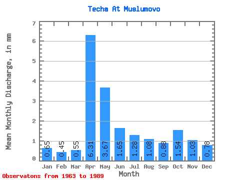
| Units: | m3/s |
| Statistic | Jan | Feb | Mar | Apr | May | Jun | Jul | Aug | Sep | Oct | Nov | Dec | Annual |
|---|---|---|---|---|---|---|---|---|---|---|---|---|---|
| Mean | 0.66 | 0.46 | 0.55 | 6.31 | 3.67 | 1.66 | 1.28 | 1.08 | 0.88 | 1.54 | 1.03 | 0.78 | 25.40 |
| Standard Deviation | 0.77 | 0.67 | 1.12 | 4.17 | 2.65 | 1.32 | 1.69 | 1.12 | 0.81 | 2.29 | 1.43 | 1.00 | 10.78 |
| Min | 0.01 | 0.00 | 0.00 | 1.22 | 0.46 | 0.25 | 0.04 | 0.05 | 0.03 | 0.07 | 0.00 | 0.05 | 12.39 |
| Max | 2.69 | 2.31 | 4.95 | 17.35 | 10.67 | 5.10 | 7.40 | 4.49 | 4.09 | 12.27 | 7.38 | 4.22 | 44.61 |
| Coefficient of Variation | 1.17 | 1.47 | 2.03 | 0.66 | 0.72 | 0.80 | 1.32 | 1.04 | 0.92 | 1.48 | 1.39 | 1.28 | 0.42 |
 Return to R-Arctic Net Home Page