|
|
|||||||||||||||||
| Point ID: 7193 | Downloads | Plots | Site Data | Code: 12160 |
|
|
|||||||||||||||||
| Download | |
|---|---|
| Site Descriptor Information | Site Time Series Data |
| Link to all available data | |
| View: | Time Series | All |
| Units: | m3/s |
| Statistic | Jan | Feb | Mar | Apr | May | Jun | Jul | Aug | Sep | Oct | Nov | Dec | Annual |
|---|---|---|---|---|---|---|---|---|---|---|---|---|---|
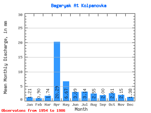
| Mean | 1.21 | 0.91 | 1.74 | 20.29 | 6.66 | 3.09 | 3.14 | 2.55 | 2.00 | 2.61 | 2.15 | 1.38 | 48.38 |
| Standard Deviation | 0.55 | 0.45 | 1.91 | 11.70 | 4.67 | 1.43 | 2.60 | 2.30 | 0.94 | 2.00 | 1.61 | 0.69 | 18.34 |
| Min | 0.26 | 0.08 | 0.43 | 4.38 | 1.62 | 0.85 | 0.56 | 0.56 | 0.57 | 0.74 | 0.66 | 0.34 | 16.28 |
| Max | 2.31 | 1.69 | 10.26 | 45.10 | 23.99 | 7.04 | 13.62 | 13.78 | 5.02 | 12.01 | 7.97 | 2.93 | 95.79 |
| Coefficient of Variation | 0.45 | 0.49 | 1.10 | 0.58 | 0.70 | 0.46 | 0.83 | 0.90 | 0.47 | 0.77 | 0.75 | 0.50 | 0.38 |
 Return to R-Arctic Net Home Page