|
|
|||||||||||||||||
| Point ID: 7191 | Downloads | Plots | Site Data | Code: 12155 |
|
|
|||||||||||||||||
| Download | |
|---|---|
| Site Descriptor Information | Site Time Series Data |
| Link to all available data | |
| View: | Time Series | All |
| Units: | m3/s |
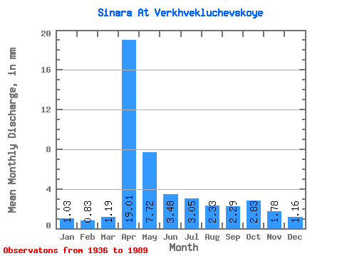
| Statistic | Jan | Feb | Mar | Apr | May | Jun | Jul | Aug | Sep | Oct | Nov | Dec | Annual |
|---|---|---|---|---|---|---|---|---|---|---|---|---|---|
| Mean | 1.03 | 0.84 | 1.19 | 19.01 | 7.72 | 3.48 | 3.05 | 2.33 | 2.29 | 2.83 | 1.78 | 1.16 | 47.52 |
| Standard Deviation | 0.58 | 0.42 | 0.98 | 12.59 | 7.62 | 2.70 | 2.77 | 1.97 | 1.90 | 2.90 | 1.09 | 0.61 | 28.33 |
| Min | 0.20 | 0.17 | 0.21 | 1.96 | 1.23 | 0.69 | 0.46 | 0.53 | 0.48 | 0.48 | 0.42 | 0.09 | 12.13 |
| Max | 2.95 | 2.20 | 6.75 | 62.21 | 42.10 | 15.66 | 16.50 | 10.23 | 8.24 | 18.48 | 4.99 | 2.91 | 151.76 |
| Coefficient of Variation | 0.56 | 0.50 | 0.82 | 0.66 | 0.99 | 0.78 | 0.91 | 0.85 | 0.83 | 1.03 | 0.61 | 0.53 | 0.60 |
 Return to R-Arctic Net Home Page